Holy Land: New Testament Then & Now Relief Map
2018-06-01
Publisher Description
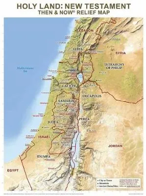
Rose Publishing's Then and Now (R) Relief Maps show the physical details of Bible places including mountains, valleys, rivers, and deserts. See where Bible places are today: red print lines show the major cities and boundaries of modern countries. This relief map focuses on the land of Israel in the New Testament time, with present-day locations overlaid in red.Printed on heavy chart paper and laminated for durability; you can use water soluble markers to write on and wipe off with ease. Includes reproducible worksheets on the back, a great reference tool for classrooms and teaching.
$24.99
$24.99
Click & collect: Select your store
Get information on product availability in store.

.png&w=64&q=75)
.png&w=64&q=75)

.png&w=48&q=75)
Publisher Description
Rose Publishing's Then and Now (R) Relief Maps show the physical details of Bible places including mountains, valleys, rivers, and deserts. See where Bible places are today: red print lines show the major cities and boundaries of modern countries. This relief map focuses on the land of Israel in the New Testament time, with present-day locations overlaid in red.Printed on heavy chart paper and laminated for durability; you can use water soluble markers to write on and wipe off with ease. Includes reproducible worksheets on the back, a great reference tool for classrooms and teaching.